Fair Highlights
This item offered for sale by:
Maps Perhaps
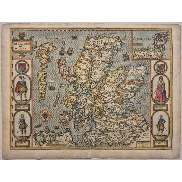
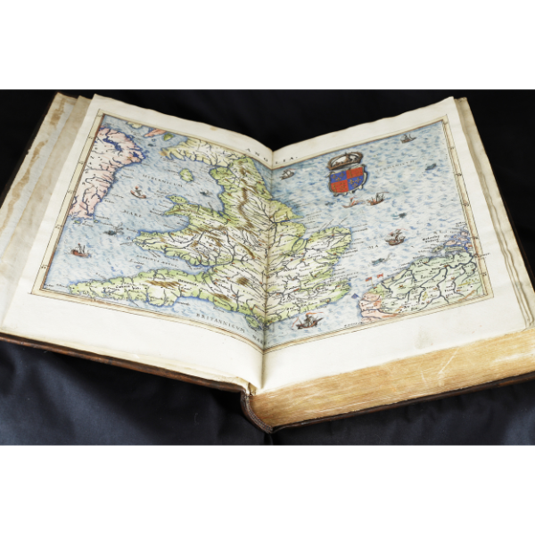
The Kingdome of Scotland – ca 1627 – John Speed
Coloured map of Scotland from a ca 1627 George Humble edition John Speed’s famous atlas of the British Isles entitled “Theatre of the Empire of Great Britain”. Surely the most decorative map of Scotland, it is the first state of the map showing portraits of James I, Queen Anna and their sons. This version of the map appeared in the atlas until 1652, at which time the four royal portraits were replaced with pictures of commoners.
£1,900
£1,900
This item offered for sale by:
Barry Lawrence Ruderman - Antique Maps, Inc.
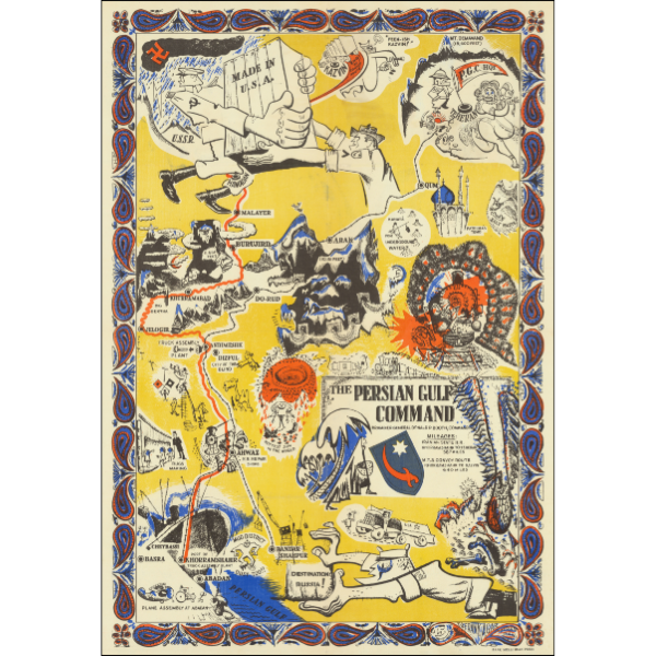
AGAR, Frank / BANK MELLI IRAN PRESS
The Persian Gulf Command
This rare World War II poster map is a vivid hybrid of geographic information, pictorial vignette, and overt symbolic messaging.
At center is a stylized map of southern and central Iran and the Persian Gulf, showing place-names, convoy routes, industrial scenes, and environmental motifs. The title block includes a shield emblem and logistical notes, including mileages for the Iranian State Railroad (Khorramshahr to Tehran, 587 miles) and the M.T.S. Convoy Route (Khorramshahr to Kazvin, 640 miles). These two routes trace the movement of Allied matériel from Gulf ports northward toward the Soviet frontier.
$2,400
$2,400
This item offered for sale by:
Barry Lawrence Ruderman - Antique Maps, Inc.
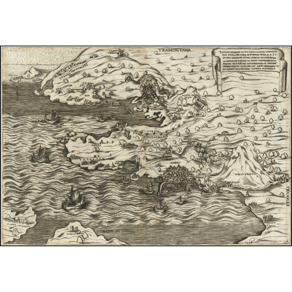
SALAMANCA, Antonio (1479 - 1562)
The First Map of the Bay of Naples
Il Vero Disegnio In Sui Propio Luogho Ritratto Del In Felice Paese Di Posuolo Quale E. M. 60 et del Monte di Duovo Nato In Mare Et In Terra , , , 28 De Setenbre 1538 . . .
The First Cartographic Depiction of a Contemporary Major Volcanic Event
Rare early map of the Bay of Naples and environs, showing the contemporary eruption of the Phlegraean Fields in September of 1538. This is also the first printed map to focus in as much detail on the city of Naples; the first true map of the city would not be published until twenty-two years later.
$17,500
$17,500
This item offered for sale by:
Angelika C. J. Friebe Ltd
.png)
Christmas Map of the World:
‘A Merry Christmas and a Happy New Year’
World Map, printed on cotton, with rolled hems, 34 x 34 cm.
Printed in France, c 1950s.
This seems to have been a promotional gift to clients: the banner at the bottom of the kerchief is left blank, possibly for the name of the company to be added.
Very unsual!
£125
£125
This item offered for sale by:
Gonzalo Fernandez Pontes
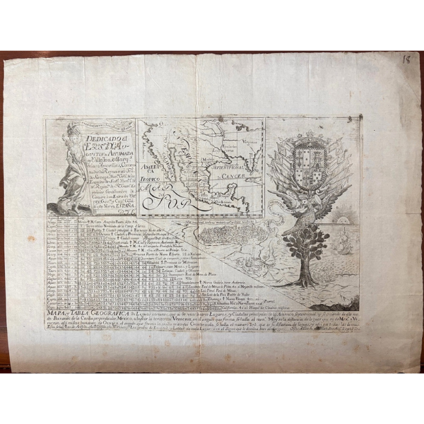
Joseph Nava( engraver): " Mapa y tabla geografica de leguas comunes que ai de unos a otros lugares y ciudades de la America Septentrional.... printed at Puebla de los Angeles ( Mexico) by Joseph Nava in 1755. The map is dedicated to the Viceroy Agustin de Ahumada y Villalon who was in care for the restoration of roads along the New Spain Viceroyalty. The map is divided in different insets with a map onthe centre part, table of distances in leagues and a view of Veracruz with a decorative tree with coat of arms of the Viceroy and cartouche with text. 39,5 x 30,5 cms. Printed on laid paper with watermark identified on paper imported from Genova ( Italy) with oval with latin cross inside and two rampants lions at sides with two circles below.
£35,000
£35,000
This item offered for sale by:
Iconic Antiques
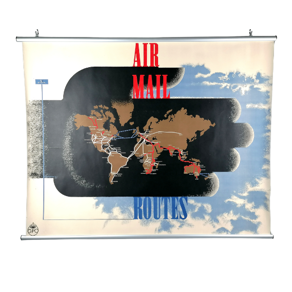
Designed by Edward McKnight Kauffer (1890-1954) for General Poster Office (GPO). Colour lithograph on paper. 1935. Quad Royal format (127cm x 101cm). Print Code P.R.D. 123.
Rarely found in Quad Royal size, this stunning art-deco poster by Edward Mcknight Kauffer shows the worldwide air mail routes from Britain in 1935, with Imperial Airways shown in red - including the route to Brisbane, Australia which had opened just months before this poster was issued. In his typical bold style, McKnight Kauffer uses a silhouette of a hand - representing the exchange of mail - as the backdrop to his very simplified map of the world.
£1,950
£1,950
This item offered for sale by:
Henry Sotheran Ltd.
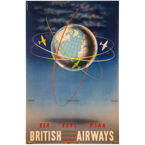
BEA BOAC BSSA - British Airways - around the world.
Artist: MORRIS, G.R.
Description: Original lithograph with colour, linen backed, printed by Chromoworks Ltd., London, 1948. 1020 x 640 mm.
£1,200
£1,200
This item offered for sale by:
Henry Sotheran Ltd.
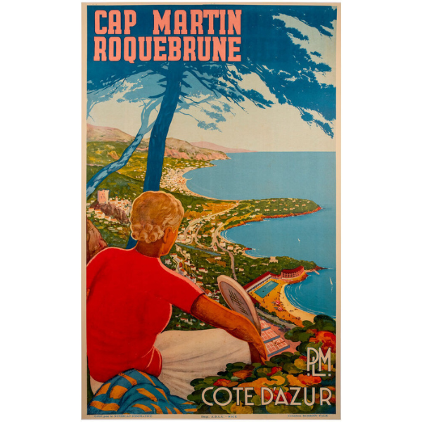
Cap Martin Roquebrune, PLM, Cote D'Azur.
Artist: REBROIN-TACK.
Description: Original lithograph with colour, linen backed, printed by A.D.I.A, Nice, c.1930. 990 x 610 mm.
£4,750
£4,750
This item offered for sale by:
Maps Perhaps
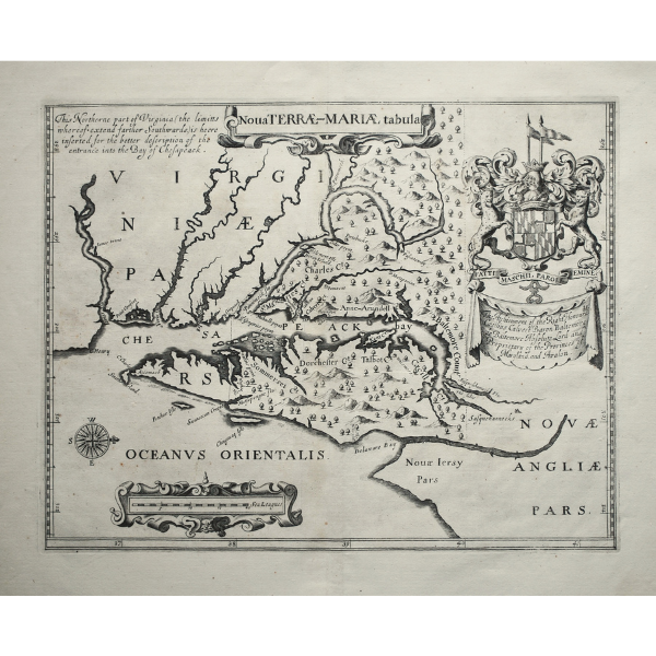
Nova Terrae-Mariae Tabula – ca 1671 – John Ogilby
Uncoloured map of Maryland from Ogilby’s atlas of the Americas entitled “America: Being The Latest, And Most accurate Description Of The New World” that was first published in 1671. Based on the 1635 Lord Baltimore Map that charted the land grant issued by Charles I to George Calvert (Lord Baltimore) for the creation of the colony in 1632, it is the earliest obtainable map of Maryland
£6,000
£6,000
This item offered for sale by:
Barry Lawrence Ruderman - Antique Maps, Inc.
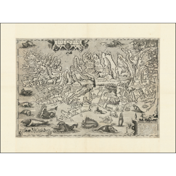
BOISSEAU, Jean
Icelandic Rarity - The Rare Boisseau Edition
Finely engraved example of this rare separately published map of Iceland, which is believed to be by Jean Boisseau, being a re-engraving of Ortelius' classic map of Iceland.
$14,500
$14,500
This item offered for sale by:
Maps Perhaps
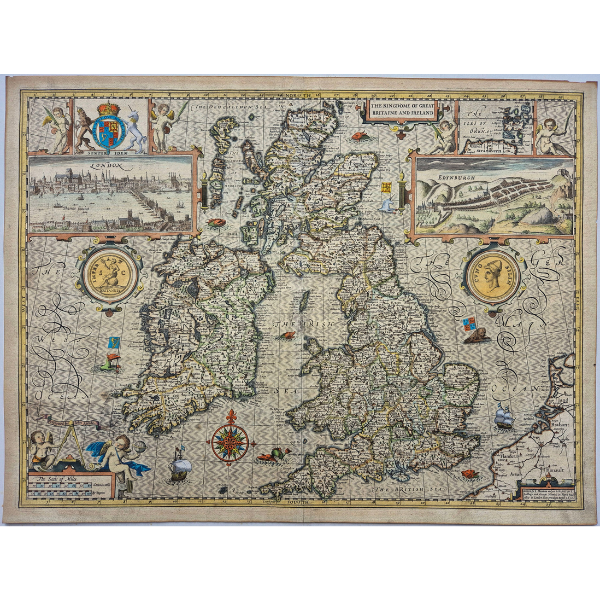
The Kingdome of Great Britaine and Ireland – ca 1627 – John Speed
Coloured map of the British Isles from a George Humble edition of John Speed’s “Theatre of the Empire of Great Britain”. The map served as a general introduction to the series of regional and county maps in the atlas. Engraved by Jodocus Hondius shortly after the union of Scotland with England and Wales, the map contains views of London and Edinburgh celebrating the union. Also shown are numerous vignette illustrations showing ships, sea monsters and coats of arms as well as ancient coins showing Britannia and "Cunobilin", Shakespeare's Cymbeline - King Coel.
£1,750
£1,750
This item offered for sale by:
Maps Perhaps
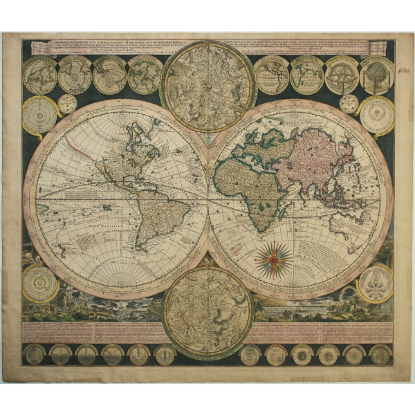
Planisphaerium Terrestre Cum Utroque Coelesti Hemisphaerio, sive Diversa Orbis Terraquei… - ca 1700 - Adam Zürner
Old coloured, double hemisphere map of the world by Adam Friedrich Zürner that was prepared for Peter Schenk and included in his atlas entitled “Atlas Contractus” from ca 1700. The two main hemispheres are cartographically up-to-date and show explorers' routes, including those of Magellan, Dampier, Tasman, Gaetani and Chaumont. Nova Britannia, an island adjacent to New Guinea, is shown with an inscription saying that Dampier discovered it in 1700. Encircling the hemispheres are markings of the winds and climates, and set around the border are twenty-six smaller astronomical diagrams and hemispheres of the world according to different projections
£2,750
£2,750
This item offered for sale by:
Sanders of Oxford
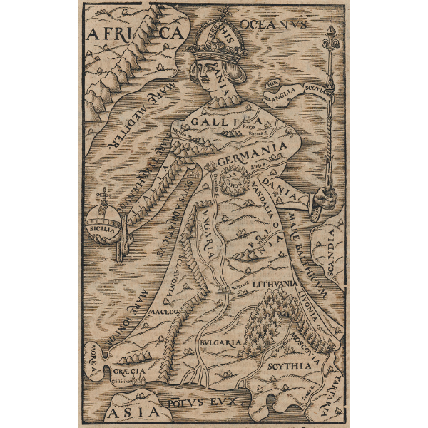
[Europa Regina]
Münster, Sebastian. Woodcut.c.1588. 258 x 165 mm
Munster’s famous cartographic curiosity, an allegorical map of Europe in the form of a queen, from a German edition of Munster’s Cosmographia.
£1,200
£1,200
This item offered for sale by:
Sanders of Oxford
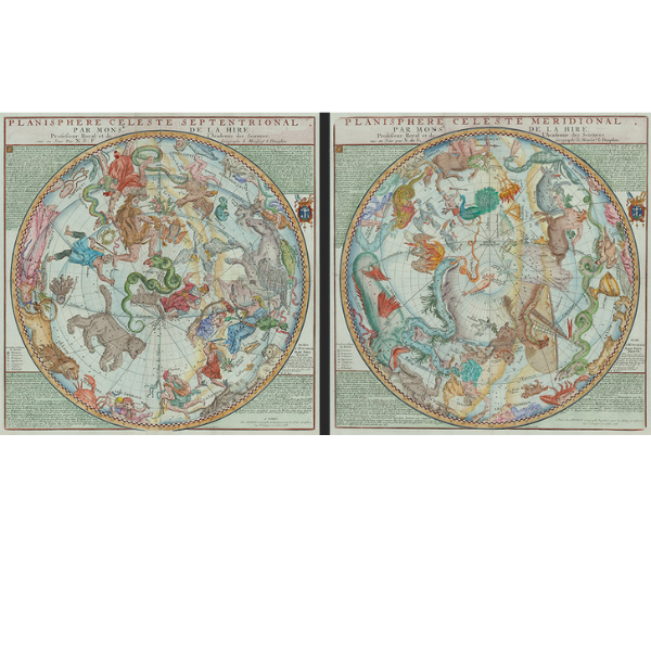
Planisphere Celeste Septentrional / Planisphere Celeste Meridional
van Loon, Harmanus after de la Hire, Philippe. Copper engraved with hand colour. Paris 1775.
~470 x 470 mm [each]
A large and very decorative pair of celestial hemispheres, northern and southern, following the astronomical observations of Philippe de la Hire
£2,250
£2,250
This item offered for sale by:
Angelika C. J. Friebe Ltd
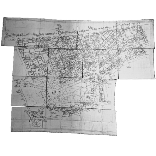
Rare manuscript map of London!
unknown artist Manuscript of Central London.
before 1941
An unfinished (?) manuscript map of London on 14 c A4-sized sheets. Ink on paper. Presented in a maroon leather case. By an unknown hand.
The map shows every bar, restaurant, coffee shop and gentleman’s club as well as landmarks and sights in the greatest of detail between Oxford Street and Victoria Embankment, and Hyde Park Corner and the Aldwych.
£1,250
£1,250
This item offered for sale by:
Angelika C. J. Friebe Ltd
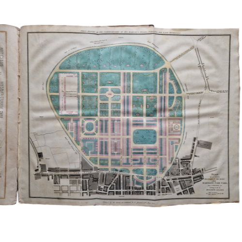
Rare Maps of early Regent’s Park.
The House of Commons First Report of the Commissioners of His Majesty's Woods, Forests, and Land Revenues; Dated 4th June 1812.
The House of Commons London 1812
folio; 4 copper engraved maps, 3 orig. hand coloured; spine broken; maps in very good cond. 158 p; complete.
£2,500
£2,500
This item offered for sale by:
Paulus Swaen Old & Rare Maps
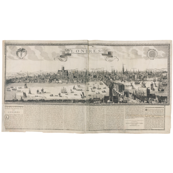
Londres 1678.
Maker: JAILLOT, Alexis Hubert.
Date: Paris, 1677
Colored Uncoloured
Size : 530x1053mm.
Extremely rare panoramic broadsheet panoramic town-view of London with underneath in letter press a description of the town's history.
The view measures more than 1 meters. The river Themes in the foreground and animated with a great variety of vessels.
The printers' address is dated 1677 but the tile has the date 1678.
A strong impression. Printed on four sheets of paper. Good margins. Paper very slightly age toned but generally very good for a separate publication. Some loss of text in the lower left corner with paper reinforced.
£45,000
£45,000
This item offered for sale by:
Barry Lawrence Ruderman - Antique Maps, Inc.
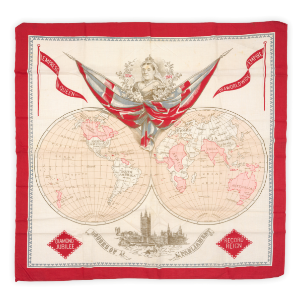
ANONYMOUS
Empress Queen of a Worldwide Empire [Diamond Jubilee / Record Reign]
Celebrating Queen Victoria's Diamond Jubilee and the British Empire
This striking printed textile map (likely produced as a commemorative handkerchief or souvenir scarf) celebrates Queen Victoria's Diamond Jubilee in 1897. The composition centers on a double-hemisphere projection of the world, specifically designed to highlight the vast global extent of the British Empire at the close of the nineteenth century.
$1,200
$1,200
This item offered for sale by:
Compass Antique Maps
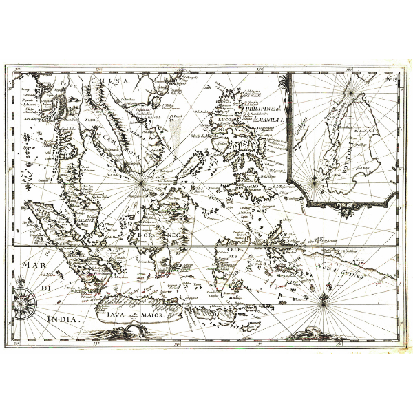
Very rare chart of Southeast Asia, aiding navigation to the Spice Islands during monsoon. Anonymous. [Untitled - Southeast Asia]. Amsterdam: JANSSON, Jan, 1621/46. Copper engraving, uncoloured. 45.0 x 31.9 cm / 17.7 x 12.6 in (neatline). Good condition.
£1,530
£1,530
This item offered for sale by:
Compass Antique Maps
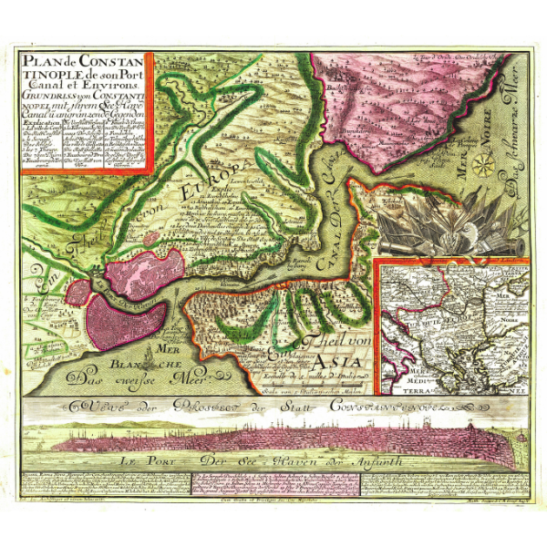
Rare and attractive triple depiction of Istanbul by Seutter. SEUTTER, Matthäus. Plan de Constantinople de son Port Canal et Environs. : Grundriss von Constantinopel mit ihrem See-Have Canal u. angränzende Gegenden. Augsburg: SEUTTER, Matthäus, c. 1740. Copper engraving, hand coloured. 55.0 x 48.4 cm / 21.7 x 19.1 in (neatline). Very good condition.
£1,615
£1,615
This item offered for sale by:
Barry Lawrence Ruderman - Antique Maps, Inc.
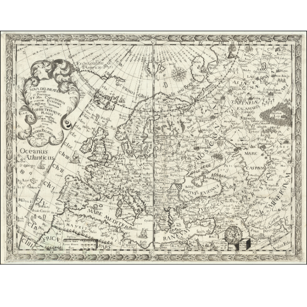
MONTECALERIO, Johannes A.
Capuchin Missions of Europe and Asia
Nova Delineatio universalis 56 Provinciarum FF. Min. Capucinorum per universam Europam…1710
Rare, idiosyncratically engraved map illustrating the fifty-six European provinces and missions of the Capuchin Order.
Produced to document the administrative structure and vast geographic reach of the Capuchin Franciscans, this striking map delineates the order's fifty-six European provinces and extensive missionary networks. Prepared originally by the Capuchin friar Giovanni da Moncalieri and later updated for publication in Milan, the map provides a comprehensive view of early eighteenth-century ecclesiastical geography. Spanning from Greenland to the deep interior of Central Asia, it employs a bold, distinctive engraving style that sets it apart from the secular cartography of its era.
$2,200
$2,200
This item offered for sale by:
Compass Antique Maps
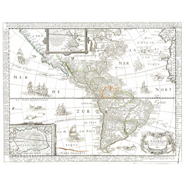
Very rare Berey map of the Americas. BEREY, Nicolas. Carte de L'Amerique Corrigeé, et augmenteé, dessus toutes les aultres cydeuant. Paris: JAILLOT, Alexis-Hubert [?], 1671. Copper engraving, hand coloured. 51.6 x 40.2 cm / 20.3 x 15.8 in (neatline). Very good condition.
£ 2,500
£ 2,500
This item offered for sale by:
Compass Antique Maps
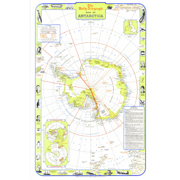
Beautiful mid-century pictorial map of Antarctica. Geographia Ltd. The Daily Telegraph Map of Antarctica. London: The Daily Telegraph, 1957. Lithography, printed colour. 46.5 x 73.0 cm / 18.3 x 28.7 in (neatline). Fine condition
£295
£295
This item offered for sale by:
Compass Antique Maps
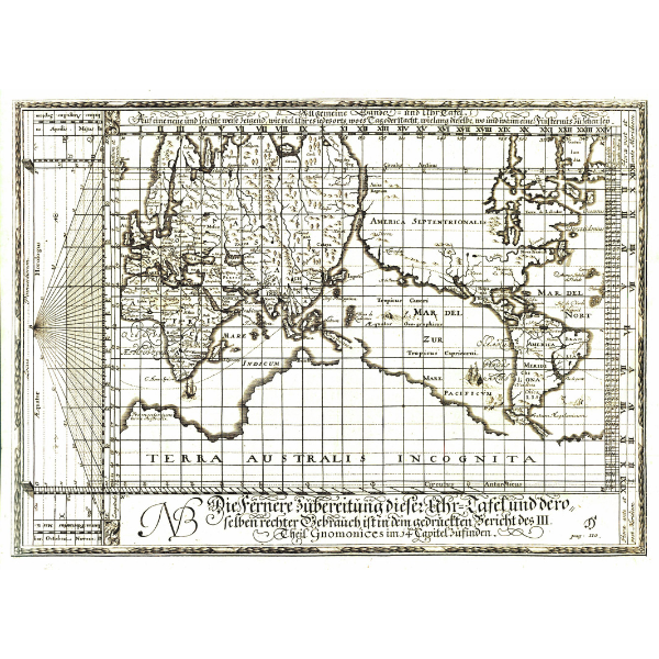
Very rare horological map of the world. Anonymous. Allgemeine Landes= und Uhr Tafel. Nuremberg: WEIGEL (the Elder), Johann Christoph, c. 1708. Copper engraving, uncoloured. 32.7 x 23.5 cm / 12.9 x 9.3 in (neatline). Very good condition.
£2,350
£2,350
This item offered for sale by:
Adam Old Prints
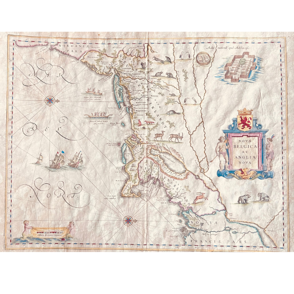
[Willem Blaeu], NOVA BELGICA ET ANGLIA NOVA.
Restored map from 1635 with gold colouring
The primary source for this work was a map produced by Adrian Block in 1614. Working for fellow fur traders within the Dutch West India Company, Block explored and mapped the coast between Cape Cod and Manhattan. His was the first map to show Manhattan as an island and to label Manhates and Niev Nederlandt. By naming Adrian Block Island, off the coast of Rhode Island, he insured continuing fame. Block used de Laet's 1630 work and Samuel de Champlain's 1612 map. Block placed north to the right as was the case with John White and John Smith's maps. Willem Janzsoon Blaeu, a Dutch cartographer, took Block's work, expanded it, and produced one of the most beautiful maps of the period. Animals such as beavers, polecats, and otters appear here for the first time on a European publication. A Mohawk village based on John White's drawings published by de Bry views for attention with sailing ships and Indian canoes. Blaeu, who was educated by the Danish astronomer Tycho Brahe, began a cartographic tradition that established his family for generations as the leading map, globe, and atlas publisher during the golden are of Dutch map making.
This item offered for sale by:
Clive A. Burden Ltd
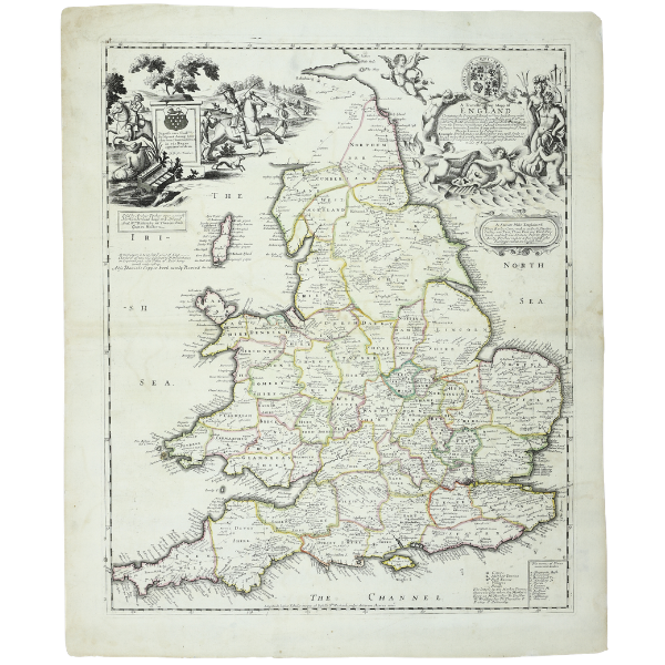
Arthur Tooker. 1680. A Travelling Mapp of England Containing the Principall Roads. ONE OF ONLY FOUR RECORDED EXAMPLES. In fine early outline colour. It is one of the earliest maps of England and Wales to incorporate roads derived the work of John Ogilby's landmark 'Britannia' atlas. The map was first published in collaboration with Robert Greene of which only one example survives.
£3,500
£3,500
This item offered for sale by:
Clive A. Burden Ltd
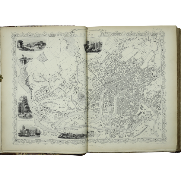
John Tallis. c.1851. The Illustrated Atlas. One of the most celebrated Victorian world atlases. The rare issue with the town plans, bound from the parts issue and including the gazetteer. It is considered the last great decorative atlas to be published. They are known for their ornate borders, vignette views, and detailed geography. Examples bound with the town plans are rare and highly desirable.
£7,500
£7,500
This item offered for sale by:
Clive A. Burden Ltd
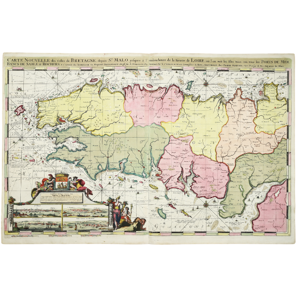
Romain de Hooghe. 1693. Carte Nouvelle des Costes de Bretagne. The most spectacular type of maritime cartography ever produced in full contemporary colour. De Hooghe was in the employ of William III. The work is considered the most expensive maritime atlas ever published in Holland. Its maps are larger and more luxuriously decorated than those of any previously published work. ‘Few great artists have turned their hands to mapmaking … Romeyn de Hooghe was an exception to the pattern. A celebrated artist from the late seventeenth century.’ (Campbell).
£3,500
£3,500
This item offered for sale by:
Clive A. Burden Ltd
Polydore Vergil. 1555. ‘ Urbinatis Anglicae historiae’. From the library of Tudor Queen Mary I. With four contemporary Tudor manuscript maps of England & Wales, Ireland, Scotland, and France dating to 1558. The maps represent the most important discovery in Tudor cartography since the appearance of the Nowell map in 1982 and completely rewrites our understanding of mapmaking skills during this period. They comprise the first reasonably accurate representations of the constituent parts of the British Isles, pre-dating the Gerard Mercator wall map of 1564, which had previously held this distinction, and often utilizing more advanced information than was known to him. On their own, each of the four maps is of exceptional cartographic importance and represent magnificent examples of Tudor visual culture, including the first separate map of Scotland, the first detailed separate map of Ireland, one of the earliest separate maps of England and Wales, and the first to present Cardigan Bay. Viewed as a whole, they represent the most important set of British maps produced during the Tudor reign and the first comprehensive mapping of the British Isles
£1,200,000
£1,200,000
This item offered for sale by:
Sanders of Oxford
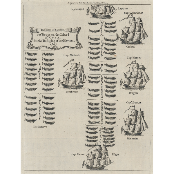
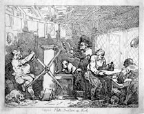
The Form of Landing,- our Troops on the Island of Cuba. for the Besieging of the Havana, 1762.
[Anonymous]
Copper engraving
Engraved for the London Magazine [Printed for R. Baldwin at the Rose in Pater Noster Row, London, 1763]
Image 249 x 188 mm, Plate 258 x 196 mm, Sheet 304 x 226 mm
A schematic representation of the British landing forces at the Siege of Havana in 1762, during the final stages of the Seven Years War, from ‘The London Magazine, or, Gentleman’s Monthly Intelligencer. Vol. XXXII. For the Year 1763.’ The illustration shows troop boats of the 35th Regiment, 56th Regiment, the Royals, the First and Second Battalions of Grenadiers, and the Light Infantry, accompanied by five ships of the line from the British Navy’s Blue Squadron, HMS Rippon under Captain Edward Jekyll, HMS Orford under Captain Mariot Arbuthnot, HMS Dragon captained by the Honble. Augustus Hervey, HMS Temeraire, recently captured from the French and placed under the command of one Captain Barton, and HMS Edgar under Captain Francis William Drake. A reserve force of the 60th Regiment and the Third Battalion of Grenadiers is shown guarded by HMS Pembroke under Captain John Wheelock. This last is significant for having carried a young James Cook, who served as Master of the Pembroke during the early stages of the Seven Years War.
£175
£175
This item offered for sale by:
Sanders of Oxford
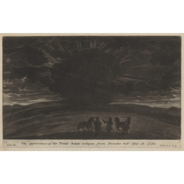
The appearance of the Total Solar eclipse from Haradon hill May 11, 1724.
Elisha Kirkall after William Stukeley
Mezzotint
[London: Printed for Messrs. Baker and Leigh, in York-Street, Covent-Garden. MDCCLXXVI] [1776]
Image 168 x 273 mm, Plate 172 x 275 mm, Sheet 218 x 359 mm
A stunning mezzotint representation of the total solar eclipse that occurred across the British Isles in May 1724, from William Stukeley’s ‘Itinerarium Curiosum: or, An Account of the Antiquities and Remarkable Curiosities in Nature or Art, Observed in Travels Through Great Britain.’ The engraver Elisha Kirkall, allegedly working from a drawing made in situ by Stukeley himself, makes excellent use of the gradations of light and dark achievable through mezzotint, showing the peak of the eclipse with faint rays of light escaping from behind a blanket of cloud, and the sun and moon to the extreme left of the scene. In the foreground, a group of three men and their horses observe the eclipse from the rise of Haradon Hill, now Beacon Hill, just beyond the village of Bulford on the Salisbury Plain. The figures may represent Stukeley himself, and his friend and travelling companion Edmond Halley, the celebrated mathematician and physicist, who at the time was Astronomer Royal to King George I. Because Britain continued to use the Julian calendar until after the passing of the Calendar Act in 1750, the inscription below gives the date of the eclipse as the 11th of May, 1724. In the New Style, the Gregorian calendar, this would be the 22nd of May.
The current example is the second state of Kirkall’s plate, with the figures reworked and the inscription reengraved, from the second edition of Stukeley’s ‘Itinerarium.’
£775
£775
This item offered for sale by:
Sanders of Oxford
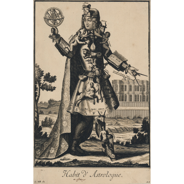
Habit d'Astrologue
Gerard Valck after Nicolas de Larmessin II
Copper engraving
G. Valk Ex. [Amsterdam, c.1695]
Image 273 x 174 mm, Sheet 276 x 178 mm
A fanciful and entertaining illustration of an astrologer, his clothes made up of items related to his profession, engraved and issued by Valck after a suite of designs by Nicolas de Larmessin II entitled “Les Costumes grotesques et les métiers.” The series shows the ‘habit’ or dress of each trade, with their elaborate costumes executed in a style reminiscent of the imaginative mannerist portraits of the Italian painter Arcimboldo from a century earlier. The current example, an astrologer, holds aloft an armillary sphere in his right hand, with a compass in his right. His long cloak is adorned with sun, moon, and star patterns, and his sleeves support open books, showing the works of Copernicus and Tycho Brahe. The rest of his attire is covered with the emblems of the zodiac. His hat is the ram, Aries. Taurus acts as the clasp for his cloak, curling around his neck. The twins of Gemini, one on each shoulder, grasp the legs of Cancer on his breast, while his breast-plate features a supine Leo. Virgo asks as a clasp for a belt made of Libra, the scale’s two pans hanging to left and right. The skirts of his coat, fringed with the alchemical symbols of each star sign, is decorated by Scorpio and a pair of centaurs representing Sagittarius. The final three signs of the zodiac occupy his stockings, with Capricorn peeking out at his knee, and Aquarius on his shin watering a pair of platformed shoes bearing the fish of Pisces. In the background, in an Arcadian landscape, is an observatory with a long telescope.
£800
£800
This item offered for sale by:
Angelika C. J. Friebe Ltd
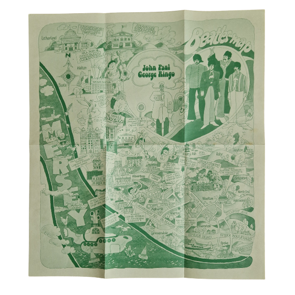
Beatles Map:
Colour printed map; 37x42cm; folds as issued.
Published by City of Liverpool Public Relations Office, 1974. Designed by Stan McCaffrey.
A fun map of Liverpool’s most famous celebs. The map was published 4 years after the Fab Four split up, and shows various landmarks in their life.
£700
£700